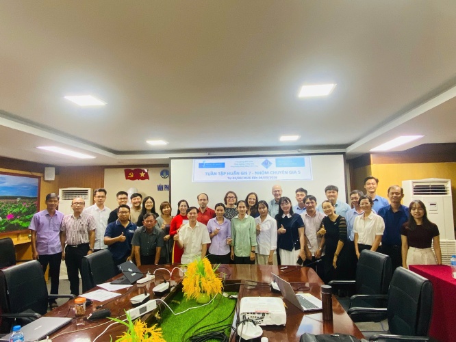
POOL 5 - WEEK 7: GIS
From March 2 to 4, 2026, the Blue Dragon Program, in collaboration with the Mekong Delta Agricultural and Rural Coordination Office and the Department of Agriculture and Environment of Can Tho city, organized a specialized training course on Geographic Information Systems (GIS).
This session marked the 7th week in an intensive series under Pool 5 of the program. The workshop attracted over 40 officials and technicians from various departments and agencies across five Mekong Delta provinces, including Can Tho, An Giang, Vinh Long, Dong Thap, and Ca Mau. The training was led by a team of distinguished experts, including Mr. Robert van Ede and Ms. Petra Hulsman from the Dutch Water Authorities (DWA), as well as Dr. Phan Kiều Diễm and Dr. Trương Trí Quang from Can Tho University, and teaching assistant.
On the first day, participants were equipped with foundational knowledge in systematic data management. The experts provided guidance on establishing a scientific folder structure to handle large datasets (up to 50GB), spanning from source data and intermediate results to final outputs.
.jpeg)
Photo: Experts guiding participants through the training modules.
(Source: Blue Dragon Program)
The second day focused on skills for extracting and downloading satellite imagery via the Copernicus Data Space Ecosystem. Participants were introduced to advanced sensors such as Sentinel-1 (Radar), capable of cloud penetration, and high-resolution Sentinel-2 (Optical) imagery. Notably, the officials practiced customizing and executing Python scripts via the OpenEO interface to automate satellite data retrieval for specific regions and timeframes- a process that significantly reduces time compared to manual methods.
.png)
.png)
Photo: Training experts providing hands-on instruction to participants.
(Source: Blue Dragon Program)
On the final day, participants applied their knowledge to a practical exercise: generating Normalized Difference Vegetation Index (NDVI) maps. Utilizing the QGIS Graphical Modeler, groups built their own automated workflows—from masking cloud-covered pixels based on SCL (Scene Classification Layer) bands to calculating minimum, maximum, and average monthly vegetation values.
This specialized knowledge holds high practical value as Mekong Delta provinces face the mounting challenges of climate change. Specifically, the use of Sentinel-1 Radar imagery enables local authorities to monitor floods, riverbank erosion, and mangrove forest fluctuations regardless of weather conditions. Meanwhile, NDVI maps derived from Sentinel-2 serve as powerful tools for the agricultural sector to assess crop health, forecast rice yields, and monitor saltwater intrusion. Mastering Python scripting and automated GIS workflows not only enhances the management capacity of local officials but also facilitates the creation of accurate, objective, and timely natural resource monitoring reports.
The closing session was honored by the presence of two program partnership managers, Mr. Tjeerd Johannes Dijkstra and Ms. Birgitte Paula de Kraker. The representatives personally observed the final group presentations and listened to the participants' reflections on their successes, challenges, and practical recommendations to optimize future training designs.
.png)
Photo: Mr. Tjeerd Johannes Dijkstra and Ms. Birgitte Paula de Kraker expressing their impression of the effectiveness of the Blue Dragon GIS training series.
(Source: Blue Dragon Program)
.png)
.png)
Photo: Participants presenting their group assignments to the management board and training experts.
(Source: Blue Dragon Program)
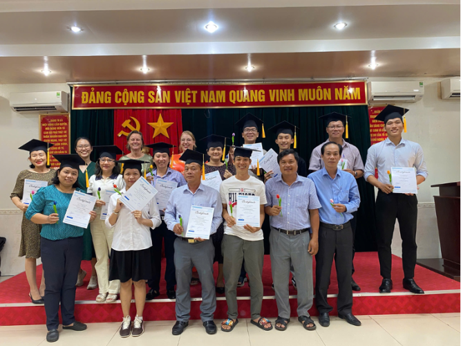
The training series concluded with great success. The Blue Dragon Program wishes to extend our sincere gratitude to our Partners and all participants for their collaborative efforts, which were instrumental to the overall success of the project.
.jpeg)
Photo: Pool 5, Week 7 participants taking a commemorative photo with experts and Blue Dragon program management.
(Source: Blue Dragon Program)
Related post
BLUE DRAGON PROGRAM MANAGEMENT MISSION ON MARCH 2026
BLUE DRAGON PROGRAM MANAGEMENT MISSION ON MARCH 2026